
Corynorhinus townsendii(Cooper, 1837)
Townsend’s Big-eared Bat
Family: Vespertilionidae
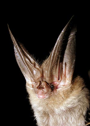 Photograph: Carson Brown
Specimens Prior to 1991
(Why two sections?)Why two different sections for specimen data?
Specimen data prior to 1991 was included in the first edition of the Bats of Texas and included only basic information. For the second edition of the book, ancillary information such as catalog number, sex, tissue numbers, etc. was collected.
Rather than mix the two sets of data into one table (which would include hundreds of empty cells for specimens prior to 1991), the two data sets were separated and formatted to best display the information.
Specimens examined, 198: Hutchinson Co.: Borger, 1 (TTU). Randall Co.: cave in Palo Duro Canyon, 1 (TCWC). Armstrong Co.: 12 mi SSE Washburn, Palo Duro Canyon, 5 (TCWC); 29 mi SSW Claude, 4 (TTU). Hardeman Co.: 13 mi N Quanah, 1 (MWSU); 2 mi SE Lazare, 1 (MWSU); 3 mi S Lazare, 3 (UIMNH); Acme, 2 (MWSU); 9 mi W Quanah, 1 (MWSU); Quanah, 1 (MWSU); 7 mi E Quanah, 2 (MWSU); 9 mi SW Quanah, 4 (TTU); 10 mi SW Quanah, 1 (MWSU); 10 mi WSW Quanah, 5 (MWSU); 11 mi WSW Quanah, 19 (MWSU); 11 mi SW Quanah, 8 (MWSU); 12 mi WSW Quanah; 7 (MWSU); 12 mi SW Quanah, 1 (MWSU); 13 mi SW Quanah, 3 (MWSU); 15 mi SW Quanah, 1 (MWSU). Foard Co.: 12 mi WSW Lazare, 3 (MWSU); 20 mi SW Quanah, 1 (MWSU). Hockley Co.: Levelland, 1 (TTU). Baylor Co.: Lake Kemp, 1 (MWSU). Garza Co.: Post, 3 (TTU). El Paso Co.: Old Tin Mine, Franklin Mts., 1 (UTEP); El Paso, 1 (UTEP). Hudspeth Co.: Upper Sloth Cave, Guadalupe Mts., 1 (TCWC); Eagle Mt. Ranch, W Van Horn, 1 (SRSU). Culberson Co.: 7 mi N Pine Springs, GMNP, 1 (TCWC); stone cabin near Grisham Hunter Lodge, GMNP, 3 (TTU); McKittrick Canyon, GMNP, 5 (4 TCWC, 1 KU); The Bowl, GMNP, 1 (TTU); Lost Mine Peak, GMNP, 1 (TTU); Manzanita Spring, GMNP, 1 (TTU); Upper Dog Canyon, GMNP, 1 (TTU). Jeff Davis Co.: 8 mi S jct. hwys. 166 and 118, 1 (TTU); 3 mi E DMSP, 1 (TTU); 3.5 mi NE Ft. Davis, 1 (TTU); 3 mi NE Ft. Davis, 2 (TTU); 17 mi W Ft. Davis, 1 (TTU); 3 mi E jct. hwys. 166 and 505, 1 (TTU). Presidio Co.: 11 mi W Valentine, 3 (TNHC); 10 mi SW Valentine, 1 (TNHC); 8 mi NE Candelaria, 1 (TCWC); 8 mi S Marfa, 1 (SRSU); San Esteban Tunnel, 1 (SRSU); Pinto Canyon, Chinati Mts., 14 mi E Ruidosa, 1 (UIMNH); Chinati Rancho, 23 mi NW Presidio, 1 (TCWC); Shafter Mine, Livingston Ranch, 19 mi N Presidio, 3 (ASVRC); 5 mi SE Bandera Mesa, 4 (MWSU). Brewster Co.: 4 mi W Alpine, 1 (SRSU); Bird Mines, Altuda, 1 (SRSU); BGWMA, 35 (3 DMNHT, 8 MSU, 24 TNHC); 4 mi NE BGWMA hdqs., 1 (DMNHT); 5.5 mi SE BGWMA hdqs., 1 (DMNHT); Oak Creek, BBNP, 4,000 ft., 3 (2 TCWC, 1 BBNHA); 3 mi NE Terlingua, 2 (SRSU); Big 38 Mine, 3 mi W Terlingua ghost town, 3 (MWSU); Chisos Mts., BBNP, 1 (LACM); Kibee Springs, BBNP, 5,700 ft., 2 (1 FMNH, 1 MVZ); 0.5 mi NW Mt. Emory, Chisos Mts., BBNP, 1 (MVZ); Emory Peak Cave, BBNP, 7,100–7,500 ft., 14 (10 TCWC, 4 UMMZ); W slope Mt. Emory, 6,500 ft., BBNP, 2 (MVZ); Sul Ross Camp House, near Boquillas, 1 (TCWC); SE slope Mariscal Mt., 2,800 ft., BBNP, 1 (MVZ); Mariscal Mines, BBNP, 1 (BBNHA). Val Verde Co.: Fisher’s Fissure, 2 mi W Langtry, 2 (TTU); Langtry, 1 (USNM/FWS); 33 mi N, 6 mi E Del Rio, 1 (TTU); E Painted Cave, 1 (USNM/FWS); mouth of Pecos River, 3 (2 MWSU, 1 TCWC).
Additional records: Collingsworth Co.: 4 mi N, 13 mi E Lutie (Hollander et al., 1987); 3 mi N, 12 mi E Lutie (Hollander et al., 1987). Cottle Co.: no specific locality (Davis, 1974). Kimble Co.: no specific locality (Davis, 1974). Presidio Co.: Sierra Vieja (Blair and Miller, 1949). Edwards Co.: Devil’s Sink Hole (Blair, 1952b).
Specimens After 1991
Download this information in CSV format(What is CSV format?)What is CSV format?
CSV stands for "comma seperated values". It is a format that allows spreadsheet and database programs to easily import data for further use. Download specimen data in CSV format for viewing in your spreadsheet or database program.